Arctic Regional Synopsis
Regional charts and associated synopsis write-up capture ice and environmental conditions throughout the Arctic which are based on the U.S. National Ice Center’s weekly analysis. Charts and synopses are updated weekly on Fridays. Note: Baltic Sea analysis is provided by the Finnish Meteorological Institute. The Canadian Archipelago (Canada East, Canada North, Canada West, and Hudson Bay) analysis is provided by the Canadian Ice Service.
Regional Quick Access
Baltic Sea
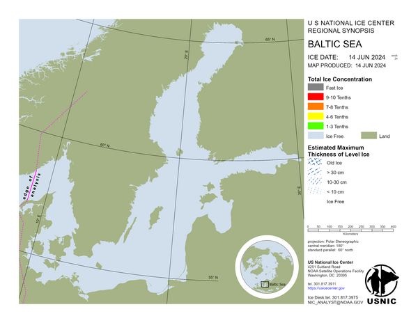
In the Northern Bay of Bothnia 30-75 cm thick fast ice and 20-40 cm thick consolidated drift ice to Kemi 2, Oulu 1 and Johan. Farther out 20-45 cm thick, in places ridged, very close ice. In the Southern Bay of Bothnia 20-40 cm thick fast ice in the archipelago. From Kokkola lighthouse to the Quark is a zone of new ice. Farther out 15-35 cm thick, in places ridged, very close ice. In the Quark 10-30 cm thick, in places ridged, close and very close ice, and thin level ice. In the Vaasa archipelago 20-50 cm thick fast ice and level ice to Vaasa lighthouse. In the Sea of Bothnia 15-45 cm thick fast ice and thin drift ice in the archipelago. Brash ice at the ice edge. In the Åland Sea new ice and ice formation. In the Archipelago Sea 15-40 cm thick fast ice in the inner archipelago. In the outer archipelago 5-20 cm thick level ice to Utö. From south of Utö and Bengtskär 10-30 nautical miles wide area of new ice and thin close ice. In the western Gulf of Finland 10-30 cm thick fast ice and level ice in the archipelago. Farther out 5-20 cm thick close and very close ice and thin level ice to a line that runs from 8 nautical miles south of Hanko 1 to Paldiski. In the eastern Gulf of Finland 15-40 cm thick fast ice in the archipelago. Farther out first 10-25 cm thick very close, in places ridged ice and thin level ice to Kalbådagrund, south of Tiiskeri and to Gogland and then 10-30 cm thick very close ice to the Estonian coast. In the Lake Saimaa 20-40 cm thick ice.
Barents Sea
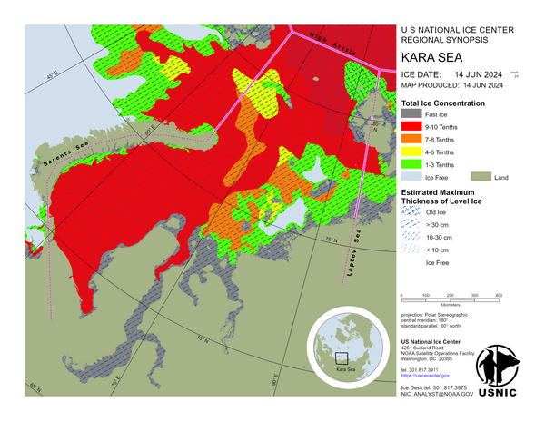
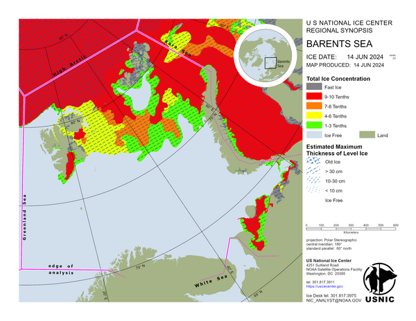
In the northern Barents Sea the sea ice drift is southwestward. Polynyas forming on the lee side of island like Franz Josef Land and Svalbard have rapidly developed young sea ice in air temperatures as cold as -20°C and colder. Ice conditions along the western shore of Novaya Zemlya continue to experience consistent development. In the southern Barents Sea air temperatures range from -16°C to -22°C allowing for rapid ice thickness growth. The ice edge has not drastically changed shifting plus or minus 15 nautical miles from the previous week.
Bering Sea
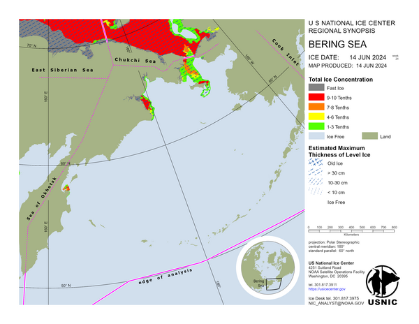
This week has allowed sea ice along Kamchatka to expand further from the coastline. Warmer air temperatures near the eastern Bering Sea lead to a significant retreat of the ice edge by approximately 61 NM. Areas that were previously covered by thin first-year ice have experienced accelerated melting.
Canada East
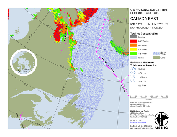
Eureka Sound and Jones Sound contain first-year ice and some old ice. Lancaster Sound, Baffin Bay and Davis Strait contain mostly first-year ice with some young and old ice present. Frobisher Bay contains a mixture of first-year and young ice. A trace of old ice is present around Resolution Island. The Labrador Sea is bergy water.
Canada West
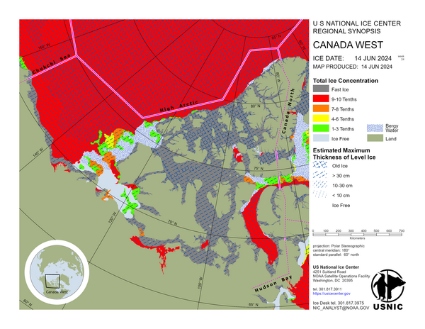
The waters around the Queen Elizabeth Islands are fast old ice and first-year ice. M’Clure Strait and Viscount Melville Sound contain predominantly fast old ice with some firstyear ice. Barrow Strait is fast first-year ice with some old ice in the western section; in the eastern section there is mobile first-year ice with a trace of old ice. M’Clintock Channel is fast first-year ice with a trace of old ice. Peel Sound is fast first-year ice with a trace of old ice. Victoria Strait is fast first-year ice. There is an area of mobile first-year ice in the southern section. Queen Maud Gulf and Coronation Gulf are fast first-year ice. Amundsen Gulf is mostly fast first-year ice with a trace of old ice in the northern section. Canada Basin is predominantly old ice with some first-year ice. The Beaufort Sea is predominantly first-year ice with some old ice.
Chukchi Sea
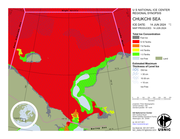
In the Chukchi Sea, frigid air temperatures persist across the region, ranging from -22°C in the south to -36°C in the north. Over the past week, buoy drift in the northern Chukchi Sea has been westward, spanning 20 to 100 nautical miles. From Point Hope southward, sea ice is drifting northward and northwestward. This northwestward drift has opened numerous polynyas along the Alaskan coast and adjacent fast ice.
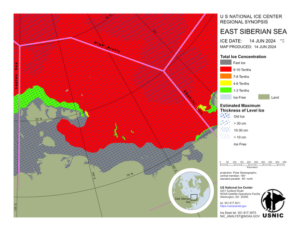
East Siberian Sea
West-southwestward drift of multiyear sea ice continues in the eastern portion (near the Chukchi Sea) of the East Siberian Sea, with some fields drifting as far as 30 NM. North of the New Siberian Islands sea ice is drifting northward. Air temperatures across the East Siberian sea are as cold as -30°C or colder, any polynyas that open are quickly frozen over with new and young ice even low concentrations of first year ice.
