Arctic Sea Ice at Maximum Extent - 2021
By LT Falon M. Essary, USN
U.S. National Ice Center
April 02, 2020
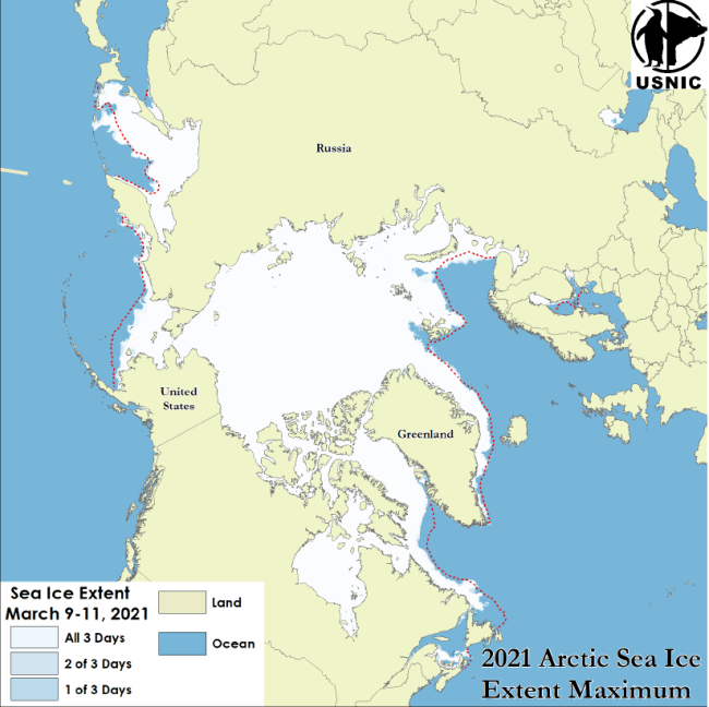
The U.S. National Ice Center has determined that the 2021 maximum Arctic sea ice extent occurred on 10 March 2021 with an area of 14.87 million square km based on analysis from the Interactive Multisensor Snow and Ice Mapping System (IMS).
The IMS is a binary analysis of ice and snow cover over the Northern Hemisphere. This year’s analysis indicated a maximum 3-day average of 14.87 million square kilometers recorded on 09 March through 11 March. USNIC uses this 3-day running mean to calculate ice extent to reduce subjectivity and variability in the determination of ice extent while providing a clear trend line. This year’s maximum is the fourth lowest recorded since 2006 when this statistic was first tracked, and is approximately 230,000 square kilometers less than last year’s maximum.
The National Snow and Ice Data Center (NSIDC), for comparison, tentatively announced on 30 March that the Arctic maximum had occurred on 21 March at 14.77 million square kilometers. The differences in the two datasets are due to the data sources used to derive sea ice extent. NSIDC uses a threshold of 15% ice coverage based on passive microwave satellite data. USNIC’s IMS uses a variety of different satellite observations which are interpreted by an analyst to determine the presence of ice at a 1km resolution.
For more information, please contact:
National Ice Center
Naval Ice Center
Command Duty Officer
Voice: (301) 943-6977
E-mail: nic.cdo@noaa.gov
Twitter: @usnatice
Facebook: @usnatice