Arctic Sea Ice at Minimum Extent - 2024
By LTJG Garner Fleming, US Navy
U.S. National Ice Center
September 27, 2024
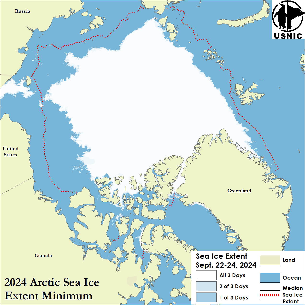
The U.S. National Ice Center (USNIC) has determined the 2024 minimum Arctic sea ice extent occurred in late-September 2024 with an area of 4.42 million square kilometers based on analysis from the USNIC’s Interactive Multisensor Snow and Ice Mapping System (IMS), used in the Multisensor Analyzed Sea Ice Extent (MASIE) product, jointly created with the National Snow and Ice Data Center (NSIDC).
Analyses for the 2024 melt season indicated a minimum 3-day average of 4.42 million square kilometers between 22 September and 24 September. USNIC minimum ice extent is determined based on a 3-day average to account for short-term spatial variability in the sea ice edge location. The 2024 Arctic sea ice extent minimum is the ninth lowest recorded since 2006 when this metric from IMS was first tracked consistently. The 2024 minimum occurred 7 days later than the 18 year average minimum date of 16 September, and is the second latest recorded date of the minimum, and the latest since the 2006 minimum, which was between 23 September and 25 September 2006.
The NSIDC, for comparison, announced on 24 September that the Arctic minimum had occurred on 11 September at 4.28 million square kilometers. This estimate, notably different from the USNIC estimate, is based on a 25-kilometer resolution ice concentration product from satellite microwave radiometers. USNIC’s IMS uses a variety of different satellite observations which are interpreted by an analyst to determine the presence of ice at a 1km resolution. Passive microwave radiometers can struggle to capture new ice formation, especially along coastal areas. This year featured the formation of new ice within the Canadian Archipelago and around Greenland following 11 September, which subsequently melted out; this was captured by high resolution imagery within the IMS analysis, leading to the later observed minimum. The difference also stems from the varying missions of each institution, the methodology, and the spatial resolution of the data sources used to identify the presence of sea ice.
To access daily products, weekly products, archival data and much more of USNIC data in various formats, visit the USNIC webpage at: https://usicecenter.gov/Products
For more information, please contact:
National Ice Center
Command Duty Officer
Voice: (301) 943-6977
E-mail: nic.cdo@noaa.gov
Twitter: @usnatice
Facebook: @usnatice
The U.S. National Ice Center is a tri-agency center operated by the Navy, NOAA, and Coast Guard and provides global to tactical scale ice and snow products, ice forecasting, and related environmental intelligence services for the United States government.