Arctic Sea Ice at Minimum and Maximum Extents (2025–2026)
LTJG Jared Doris, USN
NIC.PAO@noaa.gov
301-943-6977
March 27, 2026
The U.S. National Ice Center (USNIC) has determined the 2025 minimum and 2026 maximum Arctic sea ice extents based on analysis from the USNIC’s Interactive Multisensor Snow and Ice Mapping System (IMS), used in the Multisensor Analyzed Sea Ice Extent (MASIE) product, jointly created with the National Snow and Ice Data Center (NSIDC).
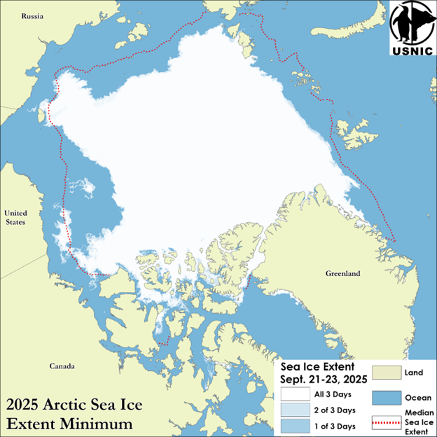
Analyses for the 2025 melt season indicated a minimum 3-day average sea ice extent of 4.86 million square kilometers between 21 September and 23 September. USNIC minimum ice extent is determined based on a 3-day average to account for short-term spatial variability in the sea ice edge location. The 2025 Arctic sea ice extent minimum is the fifth highest recorded since 2006 when this metric from IMS was first tracked consistently. The 2025 minimum occurred 5 days later than the 19-year average minimum date of 17 September and is tied with 2010 as the third latest recorded date of the minimum.
The NSIDC, for comparison, announced on 17 September that the Arctic minimum had occurred on 10 September at 4.60 million square kilometers. This estimate, notably different from the USNIC estimate, is based on a 25-kilometer resolution ice concentration product from satellite microwave radiometers. USNIC’s IMS uses a variety of different satellite observations, interpreted by an analyst to determine the presence of ice at a 1-kilometer resolution. The difference also stems from the varying missions of each institution, the methodology, and the spatial resolution of the data sources used to identify the presence of sea ice.
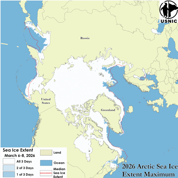
Analyses for the 2025/2026 winter season indicated a maximum 3-day average sea ice extent of 14.53 million square kilometers between 6 March and 8 March. USNIC maximum ice extent is determined based on a 3-day average to account for short-term spatial variability in the sea ice edge location. The 2026 Arctic sea ice extent maximum is the second lowest recorded since 2006 when this metric from IMS was first tracked consistently. The 2026 maximum occurred around the same time as the 20-year average maximum date of 09 March.
The USNIC analyst-driven IMS MASIE estimate is corroborated by the NSIDC, who announced that Arctic sea ice likely reached its maximum extent for 2026 at 14.29 million square kilometers on 15 March1. This estimate, slightly different from the USNIC estimate, is based on a 25-kilometer resolution ice concentration product from satellite microwave radiometers. USNIC’s IMS uses a variety of satellite observations that are interpreted by an analyst to determine the presence of ice at a 1-kilometer resolution. The slight differences also stem from the varying missions of each institution, the methodology, and the spatial resolution of the data sources used to identify the presence of sea ice.
To access daily products, weekly products, archival data and much more of USNIC data in various formats, visit the USNIC webpage at: https://usicecenter.gov/Products
For more information, please contact:
National Ice Center
Command Duty Officer
Voice: (301) 943-6977
E-mail: nic.cdo@noaa.gov
Twitter: @usnatice
Facebook: @usnatice
The U.S. National Ice Center is a multi-agency center operated by the Navy, NOAA, and Coast Guard and provides global to tactical scale ice and snow products, ice forecasting, and related environmental intelligence services for the United States government.