Iceberg A-69B Has Broken in Half and Calved A-69C
By LT Falon M. Essary, USN
NIC.PAO@noaa.gov
U.S. National Ice Center
October 28, 2021
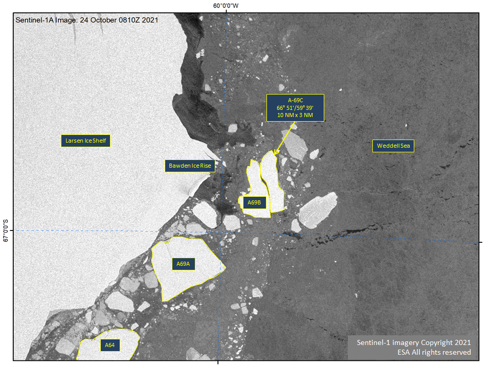
SUITLAND, MD — The U.S National Ice Center (USNIC) confirmed that A-69B has broken into another nameable iceberg, A-69C. A-69C is located at 66°51’ South, 59°39’ West, in the Weddell Sea. It measures 10 nautical miles on its longest axis and 3 nautical miles on its widest axis.
A-69C was first spotted by USNIC Ice Analyst, Angela Ottoson, and confirmed by USNIC Ice Analyst, Chris Readinger using the Sentinel-1A image shown below.
Iceberg names are derived from the Antarctic quadrant in which they were originally sighted. The quadrants are divided counter-clockwise in the following manner:
A = 0-90W (Bellingshausen/Weddell Sea)
B = 90W-180 (Amundsen/Eastern Ross Sea)
C = 180-90E (Western Ross Sea/Wilkesland)
D = 90E-0 (Amery/Eastern Weddell Sea)
When first sighted, an iceberg’s point of origin is documented by USNIC. The letter of the quadrant, along with a sequential number, is assigned to the iceberg. For example, C-19 is sequentially the 19th iceberg tracked by USNIC in Antarctica between 180-90E (Quadrant C).
Icebergs with letter suffixes have calved from already named icebergs, where the letters are added in sequential order. For example, C-19D is the 4th iceberg to calve off the original C-19 iceberg.
For more information, please contact:
National Ice Center
Command Duty Officer
Voice: (301) 943-6977
E-mail: nic.cdo@noaa.gov
Twitter: @usnatice
Facebook: @usnatice
The U.S. National Ice Center is a tri-agency center operated by the Navy, NOAA, and Coast Guard and provides global to tactical scale ice and snow products, ice forecasting, and related environmental intelligence services for the United States government.