Arctic Regional Synopsis
Regional charts and associated synopsis write-up capture ice and environmental conditions throughout the Arctic which are based on the U.S. National Ice Center’s weekly analysis. Charts and synopses are updated weekly on Fridays. Note: Baltic Sea analysis is provided by the Finnish Meteorological Institute. The Canadian Archipelago (Canada East, Canada North, Canada West, and Hudson Bay) analysis is provided by the Canadian Ice Service.
Regional Quick Access
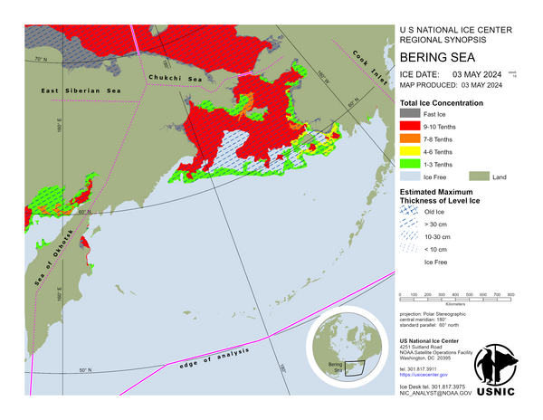
Bering Sea
The Bering Sea is ice free. A small strip of sea ice remains along the Russian shore within the Bering Strait.
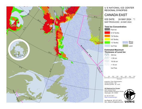
Canada East
The Labrador Sea contains bergy water. Frobisher Bay contains mostly bergy water with some old and first-year ice present at its entrance. Foxe Basin contains first-year ice with many open water areas present. Northern and eastern Baffin Bay contain bergy water while southwestern Baffin Bay contains mostly first-year ice with some old ice. Western Davis Strait contains first-year ice with some old ice, while its eastern section is bergy water.
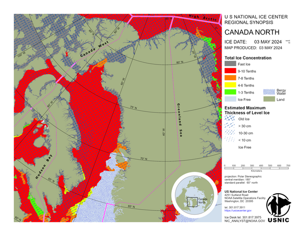
Canada North
North of Ellesmere Island contain old ice with some first-year ice. Nares Strait comprises old and first-year ice in roughly equal proportion. Eureka Sound contain first-year ice with low amounts of old ice. The ice in Jones Sound is completely mobile except for some small areas on the northern coast. Lancaster Sound is mostly bergy water. The Gulf of Boothia contains first-year ice except where a trace of old ice is present north of 71.5N. Cumberland Sound contains some old and first-year ice in its eastern section and bergy water in its western section.
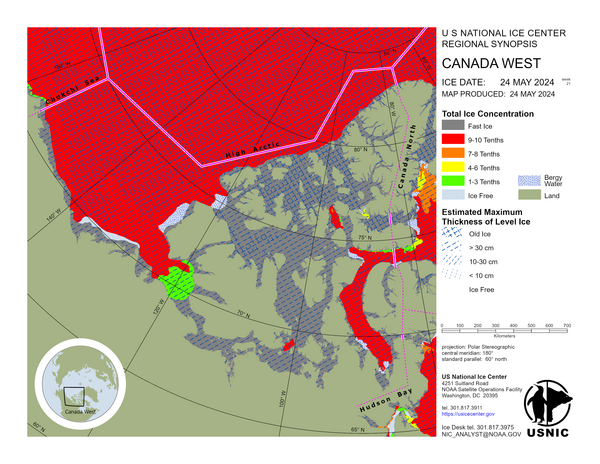
Canada West
Canada Basin comprises old ice with some first-year ice. The Beaufort Sea contains an even mixture of old and first-year ice. First-year ice is only present along the coastline of Alaska, Yukon and the Northwest Territories. Amundsen Gulf contains mostly first-year ice with low amounts of old ice. Coronation Gulf contains bergy water. Queen Maud Gulf is bergy water with some first-year ice in the northern sections. M’Clintock Channel and Peel Sound comprise mobile first-year ice with a trace of old ice. Barrow Strait contains mobile first-year ice with a trace of old ice in its eastern section, while its western section contains a mixture of old and first-year ice. Ice in M’Clure Strait is entirely mobile with an even mixture of old and first-year ice. The Queen Elizabeth Islands remains fast except for Norwegian Bay. Mobile and fasted ice comprise a mixture of old ice and first-year ice.
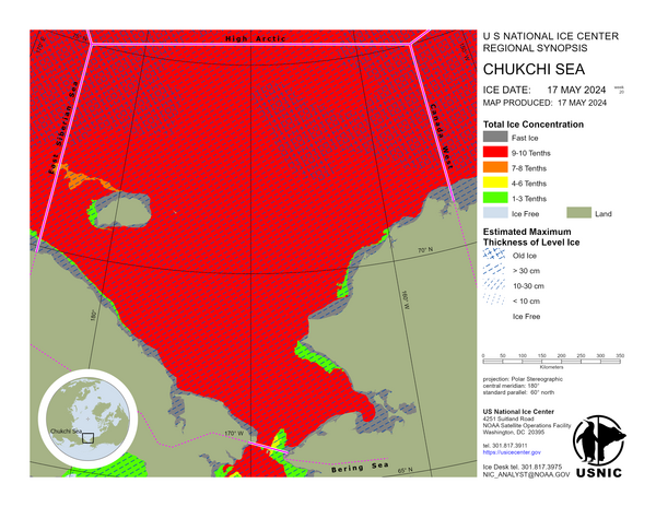
Chukchi Sea
Driven by the Beaufort Gyre, sea ice continues moving eastward and southward along the Russian coast, with a slight influx into the Bering Strait. Utqiagvik (Barrow) is experiencing ice-free waters this week.
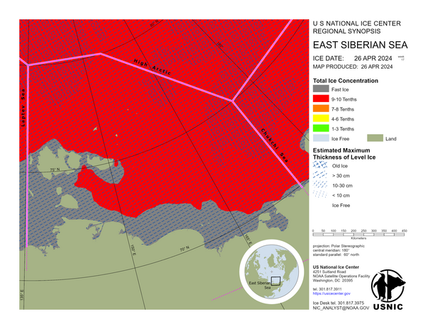
East Siberian Sea
An ice-free corridor has opened along the entire East Siberian Sea coastline. Additionally, pack ice is beginning to fracture and break up around the Anzhu Islands.
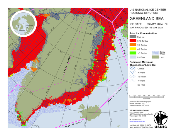
Greenland Sea
Sea ice in the Greenland region continues to drift south and melt upon encountering warmer waters.
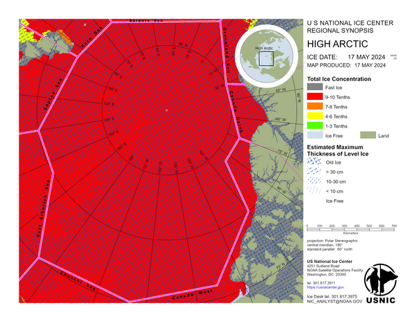
High Arctic
No synopsis write-up for the High Arctic as it remains consistent throughout this part of the year. A synopsis write-up will begin during summer months as ice retreats and becomes more dynamic in the region.
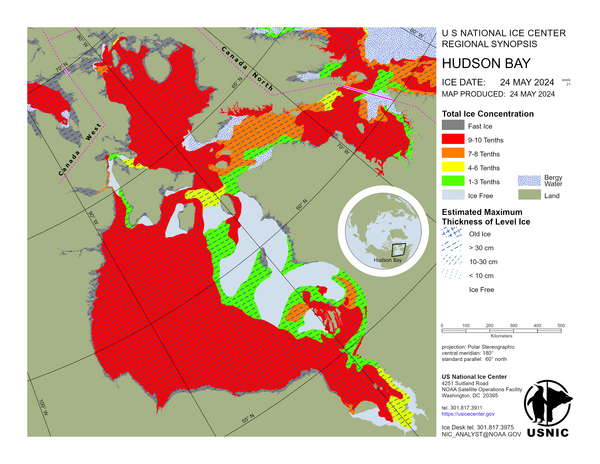
Hudson Bay
James Bay is ice free. Northern and central Hudson Bay are ice free. Southern Hudson Bay consists mostly of open water with an area of first-year ice present along the western shoreline. Some first-year ice is present in the extreme northwestern section of Hudson Strait. Otherwise, Hudson Strait and Ungava Bay consists of bergy water.
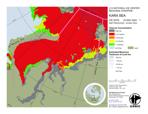
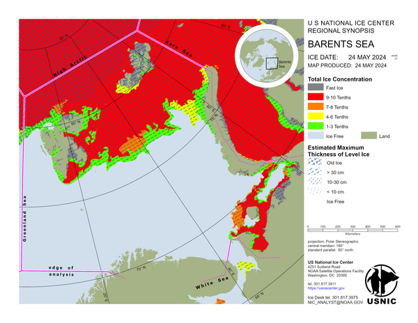
Kara Sea
The pack ice edge in the northern Kara Sea has retreated up to 90 NM eastward as a result of melting and movement due to winds. The fast ice along the mainland Russian coast has weakened and become entirely mobile, while the fast ice along Severnaya Zemlya has reduced, but remains fasted in more sheltered areas. In the southern Kara Sea, ice remains only in the vicinity of the southern portion of Novaya Zemlya, 8 NM from the coast at the closest point.
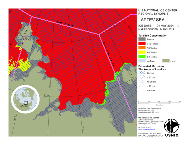
Laptev Sea
An ice-free corridor has opened along the coastline between the Lena River Delta and the Khatanga Gulf. Pack ice east of Severnaya Zemlya continues to break up and melt.