Catalog Overview
Arctic Region
Antarctic Region
Great Lakes Region
Mid-Atlantic Region
Antarctic Trivariate Charts
Product:
Average Sea Ice Trivariate Compendium Year
Average Sea Ice Trivariate Single Year
Description: Trivariate Sea Ice Presence products are derived from USNIC
archived data to provide a characterization of analyzed sea ice conditions in the polar regions. Colors
indicate that only pack ice (red), marginal ice zone (green), or ice free (blue) conditions were present.
Compendium Year - data is comprised of Daily Sea Ice information for the stated period for
every year from 2007 to the year stated
Single Year - data is comprised of the Daily Sea Ice information for the stated single year
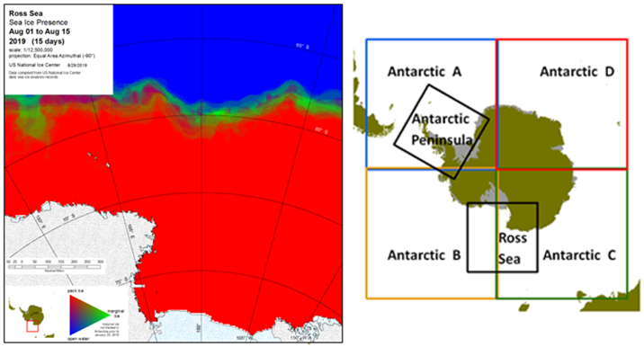
Coverage Area: The Antarctic trivariate charts are divided into six regions
for Compendium and Single Year products:
1. Antarctic Peninsula - covers Antarctic Peninsula and Weddell and Bellinghausen Seas
2. Ross Sea - covers Ross Sea and McMurdo Sound
3. Antarctic A - covers Weddell and Bellingshausen Seas
4. Antarctic B - covers Amundsen and Ross Seas
5. Antarctic C - covers Ross and Wilkesland Seas
6. Antarctic D - covers Amery Sea
Format: PDF, PNG
Periodicity: Twice a month, on the 16th and last day of the month
Dissemination: USNIC website